Leaving Erldunda the following morning we headed west to Yulara stopping at Curtin Springs roadhouse for morning tea where the majestic Mt Conner could be seen quite clearly in the distance. Mt Conner is a 700 million year old sand and rock table-top mountain or mesa which is actually three times the size of Uluru but not as well known nor as well publicised. We continued on to Yulara arriving around lunchtime at the Ayers Rock Resort which has been purpose built to serve Uluru approx 10km further down the road. The resort is spread over a large area and contains four hotels, a prestigious resort (read extremely expensive!), two campgrounds (one for coach groups only), a group of apartments and a small shopping centre and petrol station. After a quiet afternoon checking out our surrounds we climbed a small hill within the campground for our first sunset view of Uluru. Despite the distance it was still quite impressive.
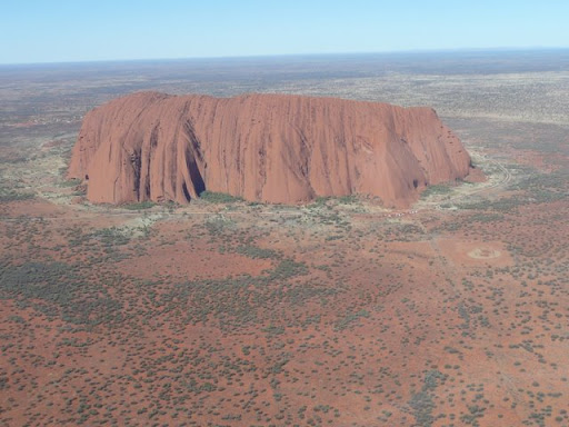
On Sunday we started our exploration of the Uluru-Kata Tjuta National Park with a half hour helicopter flight over Uluru and Kata Tjuta. Richard was in the co-pilot’s seat so was able to capture the natural beauty of this World Heritage area by taking lots of photos. After the flight we drove out to Uluru where we browsed through the Cultural Centre before driving the recommended anti-clockwise route around Uluru for our first good look at the Rock from ground level and it was HUGE!
The following day we made a very early start in order to view Uluru at sunrise. We reached the park entrance shortly after 6.00am only to find it didn’t open until 6.30am but as we were only the 3rd car to enter the Park that day we were able to find a good vantage point to view the changing colours of Uluru at sunrise. Lots more photos!
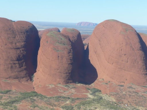
After breakfast back at the caravan we drove out to Kata Tjuta (formerly The Olgas). We stopped briefly for our first close-up view of Kata Tjuta from ground level before continuing to the western side to walk the Valley of the Winds. This 7.4km circuit walk took 2.5 hours and was quite challenging in parts but really breathtaking at the same time and well worth the effort. We were surprised by the geology of Kata Tjuta which is made up of 36 steep-sided smooth domes, the tallest being more than 200 metres higher than Uluru. The domes of Kata Tjuta are actually comprised of millions of rocks moulded together by molten rock and then eroded to a smooth finish by wind and rain. We also took the opportunity to take another walk after lunch – this time the 2.6km return walk into Walpa Gorge. This much easier walk took us into a narrow shaded gorge created by the massive walls of the two highest domes at Kata Tjuta. A small creek running through the gorge was lined with flourishing vegetation and once we reached the head of the gorge there was a great view back to the western plains.
That evening we treated ourselves to a buffet dinner at the Bough Restaurant at the Outback Pioneer Hotel where, amongst other foods, we sampled smoked kangaroo, emu sausage and crocodile salad as part of the entrée selection followed by roast kangaroo and barramundi for the main course. We followed this up with tiramisu, panacotta and cheesecake for dessert all washed down with a tasty shiraz. Needless to say we could hardly move afterwards!
Tuesday 21 July dawned clear and sunny for our 9.4km base walk around Uluru, starting out at Mala carpark which is also the starting point for the rock climb. The rock climb had been closed much of the previous few days due to high winds at the summit but this morning there were quite a few people climbing and descending the rock holding on tight to the chain handrail, their only support on the steep smooth slope. Uluru is a sandstone monolith standing 348 metres high but, like an iceberg, at least two thirds of its bulk lies below the surface.
Shortly after starting our walk we checked out a couple of small caves decorated with some faded Aboriginal rock art before taking a small diversion into Kantju Gorge where its smooth rock walls soared hundreds of metres above us. In the wet season the gorge is obviously a collection point for water pouring down the sides of the Rock which was indicated by the tide mark at the base of the rock walls. We continued our long walk around the base of the Rock checking out various rock features along the way. When we reached the three quarter mark in our base walk another short diversion took us to Mutitjulu Waterhole. This waterhole is apparently one of the more dependable waterholes and very rarely dries out probably due to its location on the southern side of the Rock and therefore protected from direct sunshine. Although the base walk was through flat terrain we still found the 2.5hour walk quite tiring especially on top of our Kata Tjuta walks yesterday.
No comments:
Post a Comment