Thursday, April 29, 2010

Kangaroo Island

We left Victor Harbour on 13 April headed south-west to Cape Jervis to catch the ferry to Kangaroo Island. The road was an up and down affair following the contours of the rolling hills past farms and extensive forest plantations before we sighted a large wind farm located close to Cape Jervis overlooking the strait called the Backstairs Passage between the mainland and Kangaroo Island. The ferry departed Cape Jervis at 1.30pm arriving at Penneshaw on Kangaroo Island a little less than an hour later. We were quite surprised to find that Richard had to reverse the caravan onto the ferry at Cape Jervis but at least we were able to drive straight off at the other end. Once on the island we followed the highway to the western end of the Island arriving at Western KI caravan park around 4.00pm. We were soon to discover that this highway was one of the few sealed roads on the Island with the majority of roads being unsealed dirt roads of varying condition.


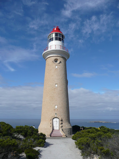
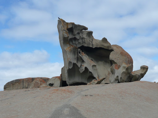
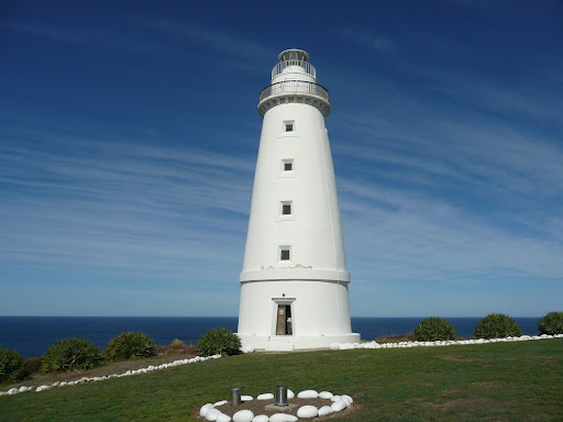
Our first day of discovery took us to Flinders Chase National Park which covers the majority of the western end of the Island. Our first stop was at the Cape du Couedic Lighthouse built in 1906 and the nearby Admiralty Arch where the limestone cliff face has been eroded to form a natural arch. The area beneath the Arch houses a large colony of New Zealand fur seals and we spent quite some time watching their antics above and beneath the crystal clear water. A nearby rock pool which was built for enjoyment by the lighthouse builders is still used today – by the seals! Then we visited Weirs Cove where a flying fox/railway had been built by the lighthouse keepers in order to transfer stores and equipment up the steep cliffs from the jetty. The goods were then stored in a small stone building at the top of the cliffs and these supplies needed to last three months until the arrival of the next supply vessel – no chance of popping down to the local shops in those days! Our next stop was at Remarkable Rocks – a formation of large granite boulders on the water’s edge which are visible from some distance away and which have been worn into weird shapes by the effects of wind and water.


In the afternoon we walked a trail which skirted Snake Lagoon before dropping down into Rocky River Valley finally bringing us to a beach on the Southern Ocean. Although the trail was only 3km long it was quite steep in places involving some rock hopping eventually taking us 1.5hrs for the return trip. The scenery was dramatic though and well worth the effort. Leaving Snake Lagoon we continued west along another 13km of corrugated dirt road to West Bay and Vennachar Point which is the most westerly point on the Island. West Bay turned out to be a lovely long white sandy beach obviously good for surfing and beach fishing and almost deserted. The nearby point was named for the sailing ship “Loch Vennachar” which sailed from Glasgow to Adelaide in 1899 and came to grief when it ran into the cliffs in stormy weather. One of more than 70 recorded shipwrecks around the Island coast.


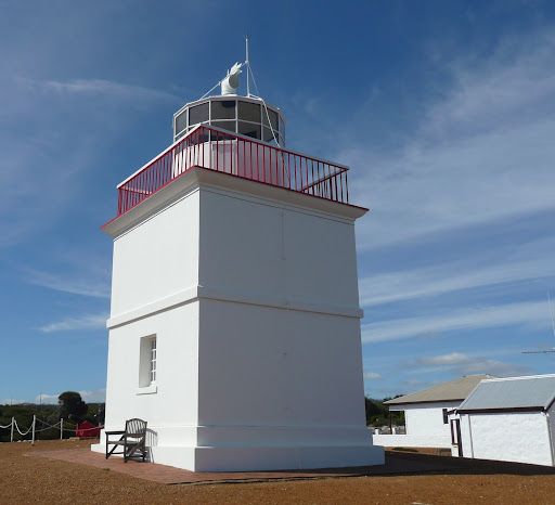
To complete our exploration of the western end of the Island the following day we visited Cape Borda Lighthouse where a National Parks guide gave us an incredibly entertaining tour of a “real” lighthouse ie still uses a revolving light as opposed to the beacons now in use at the other lighthouses on the Island. We then took in the lovely views above nearby Scott Cove towards Cape Torrens and Cape Forbin which are the highest coastal cliffs in South Australia. A little further down the road we came to Harvey’s Return which was used as a landing point for the lighthouse keepers’ stores similar to that at Weirs Cove. We tried to follow the path down to the beach but it became far too steep for safety – incredible to think of the lighthouse keepers dragging all their stores up this steep incline with only one horse to help carry the heavy loads. The story goes that they had two horses but one of them called “Harvey” always disappeared into thick bush whenever he heard the ship’s horn which signalled its arrival in the cove – only returning once all the work was done hence the name “Harvey’s Return”! There was also a Lighthouse Keepers Cemetery nearby which contained over a dozen graves of former lighthouse keepers and their families including a couple of seamen who drowned in nearby shipwrecks. On the return journey we visited Roo Lagoon Gallery where the owner turns local red gum timber into furniture, clocks, barometers. salt & pepper shakers etc. A little further down the road we called into Andermel Marron Café & Two Wheeler Creek Wines where we enjoyed a marron lunch (freshwater crayfish) accompanied by a couple of glasses of the excellent wine produced on the property. Returning to the south coast we drove out to picturesque Vivonne Bay at the mouth of the Harriet River before checking out the good quality craft and artworks at the Rustic Blue Gallery.


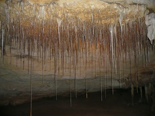
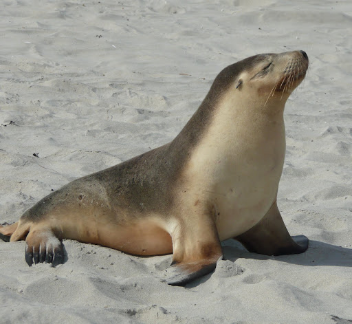
On our last day at the western end of the Island we visited the beautiful beach at Hanson Bay, one of the Island’s finest. The luxurious Southern Ocean Lodge is located nearby. We then visited Seal Bay where a National Parks ranger conducted a tour which allowed us access to the beach for a close-up view of the resident seal lions. It was an incredible experience being so close to these wonderful mammals at play in the water and on land, suckling their young and resting on the beach after their feeding forays out to sea which often last up to three days. Excellent boardwalks and viewing platforms high above the beach also gave great views of the beach and nearby dunes where the sea lions come to rest and mate. That afternoon we visited Kelly Hill Conservation Park where we took a guided tour down into the Show Cave and nearby chambers which are part of a vast underground network of limestone caves and formations.


Feeling like we had explored most of what western KI had to offer we drove to the main town of Kingscote on the eastern side of the Island. After setting up camp we drove out to Reeves Point which is the site of the first European settlement not only on Kangaroo Island but in South Australia. We also visited Hope House, an historic home built in the 1850s now owned by the National Trust. The home is now a museum with comprehensive exhibits depicting the pioneering history of the Island. As a change of pace we drove a short way out of town to Shep’s Studio, a gallery attached to the mud-brick home of local artist Neil Sheppard. His works are bright and colourful and displayed at various restaurants and galleries all over the Island. We were quite taken with his work and may consider purchasing one of his paintings once we’ve had a chance to review his whole collection online at Sheps Studio. We also visited the Kangaroo Island Gallery and the Fine Art Kangaroo Island Gallery back in Kingscote where we saw other excellent works by local artists. Finally we enjoyed a coffee break at the Island Beehive, one of Australia’s largest organic honey producers. Kangaroo Island is proudly home to the Ligurian bee first introduced to the Island in the 1800s and now the only place in the world where this pure strain of bee still survives.


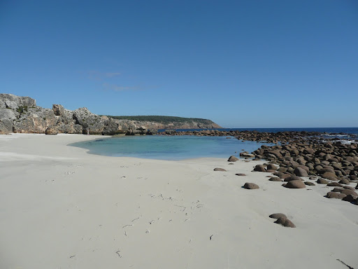
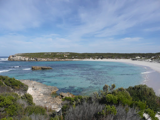
The next morning we drove to the north coast to investigate Emu Bay, Smith Bay and Stokes Bay. Emu Bay is a beautiful 4km long beach with vehicular access onto the sand and is a popular swimming and surfing spot. There didn’t appear to be any direct access to Smith Bay itself but KI Abalone had established an enormous complex there to breed abalone for the export market – unfortunately the company wasn’t successful. After a lovely drive along the coast – apart from the corrugated roads – we finally arrived at Stokes Bay which on first impression appeared to be a small rocky cove. However we followed a sign directing us to the beach which took us through a narrow tunnel amongst the rocks until we emerged onto another stunning white sandy beach with its own large natural rockpool. After a stroll along the beach we checked out the menu at the Rockpool Café before driving up the hill to Stokes Bar & Grill where we enjoyed a delicious seafood lunch sitting outside on the deck of the restaurant which had the most incredible views back over the Bay.

After lunch we continued our drive westwards along the coast until we reached King George Beach which wasn’t really as grand as its name being just a small rocky inlet but picturesque all the same. We drove on for a few more kilometres until we reached Snelling Beach at the mouth of Middle River another very popular beach for swimming and fishing. Leaving Snelling Beach we drove up to Constitution Hill which provided stunning views back over Snelling Beach and the coast. Heading inland a short distance from the coast through rolling farmlands we drove down into another valley which followed a winding riverbank to a small sandy cove called Western River Cove. As well as being a lovely surfing and fishing spot it is also popular for snorkelling and diving. That evening we shared a delicious meal of freshly caught calamari and whiting fillets courtesy of a couple from Pambula NSW who were camped next to us – how lucky are we!


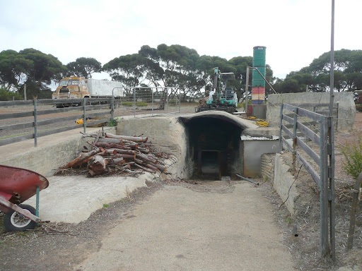
Our final day touring out of Kingscote took us to the Emu Ridge Distillery which is the only remaining commercial eucalyptus oil distillery in South Australia. During the 1930s there were 48 eucalyptus stills in operation on the Island employing over 600 people. The whole operation is quite rustic and simple to say the least but very effective. They also had a wine tasting counter for the nearby Rookery Wines vineyard so we ended up purchasing another bottle of wine as well as some eucalyptus products. Our next stop was at Clifford’s Honey Farm where we viewed an informative video on the collection and extraction process of honey and beehive by-products before sampling some yummy honey ice-cream! We then drove south a short distance to check out the secluded Flour Cask Bay on the Southern Ocean which can only be reached by a short walk through the sand dunes. In the afternoon we drove to American River, a small fishing village south-east of Kingscote. It is neither American nor does it have a river – it was named after a group of American sealers who landed there in 1803 and camped alongside a narrow inlet from the sea – at the time mistaken for a river.

On 20 April we left Kingscote for the short drive east to Penneshaw on the Dudley Peninsula which is the ferry port for Kangaroo Island where we had arrived one week earlier. Our caravan park site provided panoramic views over Hog Bay towards the Fleurieu Peninsula on the mainland – a lovely location for our last few days on KI. After relaxing in the sunshine enjoying the views in the afternoon we dined at the nearby Penneshaw Hotel that evening where the seafood meal and local wine lived up to all expectations.

The following morning we drove a short distance west of Penneshaw to Prospect Hill which was first climbed by Matthew Flinders when surveying the Island in 1802. We admired his stamina as we counted 512 steps to the lookout – however the view was well worth the effort or so we kept telling ourselves! We then drove a few kms off the highway to Pennington Bay – another superb surfing and fishing beach. We also checked out the quieter Browns Beach and Baudin Beach to the north before returning to Penneshaw where we visited Dudleys Wines cellar door for more samples of the local produce – needless to say we didn’t leave empty handed!


Our last day of sightseeing took us out to the most eastern point of the Island at Cape Willoughby where we joined another guided lighthouse tour. The views from the top of the lighthouse over the Backstairs Passage between the Island and the mainland were quite spectacular if somewhat windy! We were also surprised to see a live peacock wander out of the shrub on the side of the road – surely not a native! We then drove back to Antechamber Bay at the mouth of the Chapman River which is a favourite spot for canoeists and campers. A few kms down the road we diverted to visit Chapman River Wines which had been highly recommended to us especially for its savoury antipasto platter. We spent a very enjoyable hour or so over lunch and found their wines to be some of the best reds we’ve tasted so of course we had to purchase a few samples to take away! Another seafood dinner at the Penneshaw Hotel nicely rounded out our stay on KI. After dinner we walked down to the beach to see the fairy penguins come ashore however we were running a little late and only managed to spot two penguins waddling up the beach but the cries of many others could clearly be heard coming from their burrows in the sandhills all along the beach.


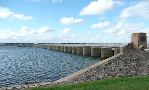
We sadly said our goodbyes to Kangaroo Island the following morning when we caught the 11.30pm ferry from Penneshaw to Cape Jervis where we stopped to have lunch before following the road into Adelaide. The highway proved to be very hilly and bumpy in places and the traffic was a jolt to our systems after the slower pace of Kangaroo Island.

Victor Harbour & Port Elliott

We left Goolwa on 11 April for the short drive along the coast to Victor Harbour located on Encounter Bay where we booked into a beachfront caravan park not far from the town centre. Victor Harbour is a very popular beachside holiday destination for South Australians and being Sunday, as well as the school holidays, the town was extremely busy. After a lunch of local fish ‘n chips we drove back along the coast to Port Elliott on Horseshoe Bay. The lookout at Freemans Nob provided magnificent views up and down the coast and we joined the Sunday crowds browsing through the handful of shops along the Strand. Once back in Victor Harbour we drove to the southern headland called the Bluff which again gave sweeping views in both directions along the coast. We also stopped on the side of the road for a while to watch a playful seal swimming very close into shore. Apparently during the winter months the Southern Right whales are also frequent visitors to Encounter Bay. The following day we enjoyed another seafood lunch in town with friends who’d driven down from Adelaide before we decided to burn some calories by walking out along the causeway to Granite Island. We were soon overtaken by a horse drawn tram which regularly carries visitors to and from the island along the causeway and is a very popular tourist attraction.

Goolwa

Arriving in Goolwa we booked into a caravan park close to the Murray River. Goolwa was settled in 1841, proclaimed a river port in 1857 and was a thriving port for paddlesteamers carrying cargo between the Murray River and the sea and also for the construction of paddlesteamers and barges. Unfortunately the importance of the port dwindled when the railway was opened between Port Adelaide and Morgan further upsteam in 1878. However it still retains the title of being the only fresh water port in the Southern Hemisphere. We walked around town in the afternoon checking out the eateries, shops etc and enjoyed a lovely meal of braised lamb shanks in Murphy’s Pub that evening. There was a slight mix-up with our table seating and the hosts were extremely apologetic to the extent that we were each given a complimentary Baileys liqueur after dinner!

First thing next morning we booked our passage on the ferry to Kangaroo Island leaving next Tuesday and were thrilled to receive free passage for the caravan – saving us approx $274. Apparently a special offer was introduced in mid-February and will apply until 30 June – what a bonus! We drove back along the highway to Strathalbyn where we spent a few hours browsing this historic town, enjoyed morning coffee at a sidewalk café and checked out the large number of antique shops where we made a couple of small purchases. Returning to Goolwa in the afternoon we drove over the bridge to Hindmarsh Island where the well established marina development is apparently the largest fresh water marina (40 hectares) in the Southern Hemisphere. Hindmarsh Island is approx 15km long and 6km wide and is unique in having fresh water on one side of the island and salt water on the other. We drove out to the Murray Mouth which is where the Murray River finally flows out to sea however sand dredging which commenced there in October 2002 is still necessary today to prevent its closure due to the low river levels. We also checked out the Goolwa Barrage & Lock – one of several barrages erected in the early 20th century to control the River’s flow.

Kingston SE

Leaving Robe the next morning headed for Kingston SE we unfortunately missed the turnoff due to a truck blocking our view of the signpost so we drove for nearly 20km before we confirmed we were headed in the wrong direction so had to retrace our steps! We drove into Cape Jaffa where a multi-million dollar canal estate has been developed complete with jetties and new breakwaters forming a channel for boats going out to sea. The only problem is that the estate seems to be in the middle of nowhere and Cape Jaffa itself consists of only a few houses and a caravan park so there are no other facilities any closer than Kingston approx 40km away. We stopped in Kingston for morning tea and some shopping and thought we’d buy some fresh lobster for which the area is famous. However, as the price of fresh lobster was between $55-$75 kg with one half lobster being priced at $62 we decided we could do without! The 150km drive along the Coorong Peninsula was fairly unremarkable until we finally sighted one of the lakes lying between the highway and the sandhills behind the beach – an aerial view would have been spectacular however there were no flights in operation. We finally reached our destination at Meningie on the shores of Lake Albert in the late afternoon.


Unfortunately it had rained quite heavily overnight and showed no signs of abating the following morning so we were quite damp by the time we’d disconnected the water, electricity etc and got underway again! The rain had eased by the time we reached the ferry which carried us across the lower reaches of the Murray River at Wellington. The roads north of Strathalbyn around Langhorne Creek showed signs of flooding from the recent heavy rains in the area and it was quite hairy driving through some sections where the water was still lying halfway across the road. Langhorne Creek is another well known winery region evidenced by extensive plantings of grapevines visible in all directions.

Robe & Beachport

On Easter Tuesday we left Naracoorte on the relatively short drive to Robe where we were fortunate to be located on a beachfront site which had beautiful views over Guichen Bay on the Southern Ocean within a short stroll to town. Robe is a very historic harbour and beachside town with many well maintained older buildings and appears to have lots of rental accommodation – obviously a very popular place in summer. We enjoyed browsing through the excellent and informative town history display in the Information Centre.


The following day we drove out past Robe Harbour and the old gaol ruins to the Obelisk which was erected to provide guidance to shipping in much the same way as a lighthouse. Being painted in red and white stripes the Obelisk is easily identifiable but the limestone cliffs on which it stands are extremely eroded so it’s expected the Obelisk will eventually fall into the sea. With that in mind a new modern lighthouse has been erected further inland. We could also see the Gateway Rock just offshore with its two arches reminiscent of London Bridge off the Great Ocean Road in Victoria. We continued driving south towards Beachport stopping to check out the Wookawine Cutting on the way. This deep cutting through a rocky hill was dug by a local farmer to drain the boggy farmland to the west and took him over 3 years to complete. Reaching Beachport we found another fishing village smaller than Robe but with a long jetty very popular with recreational fishers. It has a good surfing beach and a scenic drive along the coast to the north provides lovely views of the often wild seas of the Southern Ocean. This evening we enjoyed a seafood dinner at Robe Hotel overlooking the Bay.

Sunday, April 4, 2010

Naracoorte

Leaving Mt Gambier on Good Friday 2 April we drove due north through extensive heavily forested areas until we reached Penola with its vast tracts of grapevines and wineries at the heart of the Coonawarra wine region. We continued north to Naracoorte which apart from being famous for the World Heritage listed Naracoorte Caves surprised us with its size and heritage.

The following day we drove back to Penola to visit a few of the wineries cellar doors. After browsing around town and locating the original schoolhouse established by Sister Mary MacKillop we made our first stop at Koonara Wines where, after some judicious sampling, we purchased a few bottles of Shiraz and Sauvignon Blanc. We also visited Katnook Estate, DiGiorgio Wines and Coonawarra Wine Gallery where we bought another couple of bottles of Semillon Sauvignon Blanc.


On Easter Sunday we visited the Naracoorte Caves complex where our first tour was of the Victoria Cave with its extensive fossil deposits which earned the cave complex its World Heritage status. Next we toured the Alexandra Cave with its more spectacular formations of straws, stalactites, stalagmites, helactites, columns, flowstone and shawls – we’re becoming quite knowledgeable now! We also took a self guided tour of the Wet Cave with it enormous caverns. On the way back to town we visited a gallery with its displays of various articles including furniture made out of beautiful red gum timber.


Mt Gambier

We left Portland on 31 March for the relatively short 110km drive north-west to Mt Gambier. We booked into the BIG4 caravan park just across the road from the Blue Lake only 2mins from the city centre. The Blue Lake certainly lived up to its name – it was incredibly blue that afternoon. Apparently it is only blue during the period November – March so we were fortunate in still being able to witness it. It’s all a bit technical but as we understand it, the blueness of the water is due mainly to the increased white calcite together with a reduction in tannins in the warmer months as well as scattering of the light. The Blue Lake is the largest of the Crater Lakes which also include Valley, Brownes & Leg of Mutton Lakes however the Brownes & Leg of Mutton Lakes have now dried up. We decided to visit Centenary Tower hoping to view both Blue & Valley Lakes together however we hadn’t reckoned on the very steep climb from the carpark – another good cardio-vascular workout! The view from the Tower over the surrounding countryside was well worth the climb – you could even sight the ocean approx 25km to the south – although both lakes weren’t visible as we’d hoped.


Driving back into town we walked down into the Cave Garden right in the centre of town next to the Library and Arts Centre. This sinkhole was the original source of water for the early settlers and during winter the stormwater runoff makes a spectacular waterfall down into the Cave where it eventually enters the underground water system which possibly feeds into the Blue Lake. We also visited the Umpherston Sinkhole which was originally a cave before the roof fell in to the cave floor and created terraces which have now been landscaped into a beautiful sunken garden. Mt Gambier actually sits over a huge complex of underground limestone caves and is pockmarked with sinkholes and lakes.

The following day we drove south to Port MacDonnell the self proclaimed “Southern Rock Lobster Capital of Australia”. The first thing we noticed was how incredibly flat the whole area was – barely above sea level – with extensive breakwaters forming a safe harbour for the lobster fishing fleet. We walked around the ruins of the original lighthouse erected above the limestone cliffs at Cape Northumberland on the western side of town. However it was abandoned when the cliffs began to fall into the sea and a replacement lighthouse was built a little further inland on safer ground. There were some interesting rock formations formed by the action of the waves and fairy penguins come ashore at dusk.

On returning to Mt Gambier we visited the "Lady Nelson" Discovery Centre which houses a life-size replica of HMS Lady Nelson captained by Lieutenant Grant when it became the first vessel to sail eastward through Bass Strait. His first sighting of the Australian mainland were two mountains which he named Mt Gambier and Mt Schank to the south. The museum also held displays on the geology of the region as well as the history of the pastoral, forestry and tourism industries.